 This unit actually started at the beginning of November, but since that’s such a short month for us I planned it to take up the rest of the calendar year. I began by having all the 4th graders in each class gather around my computer at the circulation desk. I showed them the basics of how to use Google Earth. We learned how to type in locations, how to zoom in, how to check off the 3D layer and other fun layers. We looked at our school and then at some famous monuments.
The week after that they had free time to go wherever they wanted using the program. They paired up and took turns finding each others’ houses and looking up places in the world that interested them. They loved it, and it helped them really get familiar with the program.
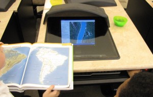
Then in December we switched gears and started using Google Earth to talk about the rainforests, which is our school-wide theme for this year. They broke into teams of 3, and I gave each of them an atlas. I told them a page number (which was for South America), and their job was to look at the atlas page, find the Amazon river, and figure out which countries it runs through. They then had to get onto Google Earth and find the river on Google Earth. They could try typing in the right keywords OR they could look at South America and figure out where the river is based on where it is in the atlas. Once they found the river they had to click on all the photos and articles near the river to learn more about rainforest conservation in the Amazon (the Global Awareness layer puts these in for them to see). There are Greenpeace, WWF, and UNEP links in addition to tons of photos and other tidbits.
They really enjoyed this unit. They excitedly called me over to see every time they found some new cool photo or piece of information. We talked about what they learned in their rainforest exploration. It was very cool.
